Officially, the Sea-tac airport — which sits only about 400 feet above sea level — received a storm total of about 2.7 inches of snow.
But Monday’s storm may soon seem like just a light dusting after a snowstorm forecast to be even larger slams the region Friday through Saturday.
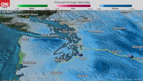
Some of the forecast models show “potentially crippling snowfall amounts for the Seattle, Everett, (and the) Tacoma area westward to the Olympics,” according to the National Weather Service in Seattle’s Thursday morning forecast.
That office has issued a winter storm watch for the area because forecasters believe significant snowfall is likely but not certain. If the forecast holds, a winter storm warning would likely come later Thursday or Friday morning.
Seattle area snowfall amounts
- 8-12 inches of snow is possible for Seattle, although there is a chance of lower amounts like the official measurement on Monday. The last time Seattle had 8 inches of snow or more in one event was in February of 1990, when 9.8 inches fell over two days. If more than one foot of snow falls, it would be the first time in five decades. Seattle has only had seven different snow events totaling a foot or more since 1894.
- Along the coastline, 3 inches of snow could fall.
- The largest amounts of over a foot of snow are possible across the Olympics and Puget Sound.
The timing of snow in Seattle metro
- The snowfall will begin north of Seattle Friday morning, with 10 inches or more possible along the north slopes of the Olympics
- By the afternoon, snow will move into the metro area.
- Snow will continue into Saturday, tapering off Saturday evening through Sunday morning.
Cold and powerful winds are other threats with this storm
The winds expected to accompany the storm could cause issues with blowing snow, as well as downed power lines and trees. The wind gusts could reach anywhere from 20-30 mph in the Seattle area, while the northern Puget Sound and Olympics region could see gusts of 60 mph.
Temperatures will drop below freezing Friday night and won’t get back above 32 degrees until Sunday.
Those temperatures, combined with the wind, could make it feel like it’s in the teens Saturday across the Seattle region.
If that wasn’t enough, there’s a possibility of more snow for Seattle Sunday into Monday.
Views: 634


